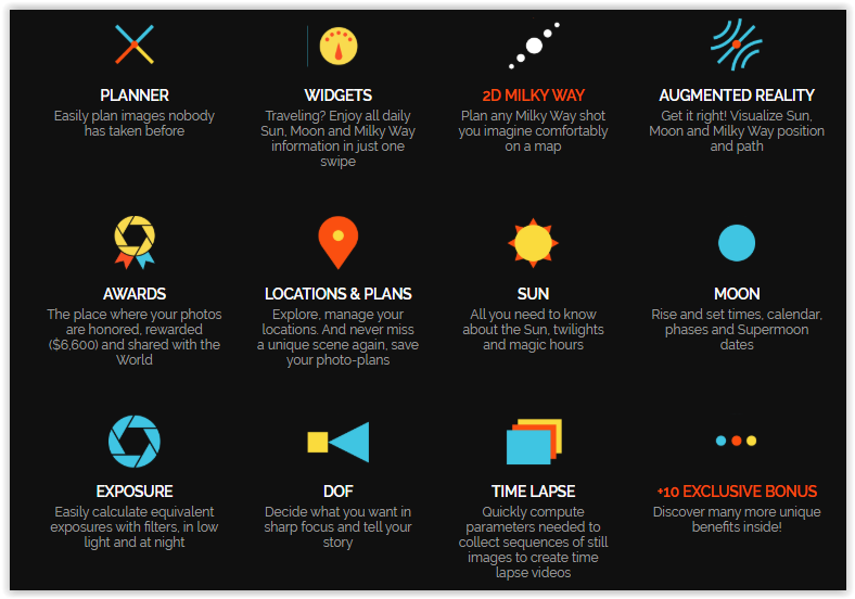
PhotoPills drone app for those who love photography. A must have app fro drones. No matter if you are a new user or with experience, this app is amazingThis little app has far too many features to cover here. But many of them are useful for drone photography.
The Planner and Sun pills are incredibly useful, allowing you to see the movement, direction, and angles of the sun at any particular time. You can plan sunrise and sunset photos, which also helps to know how much light you have.
The Planner pill now includes Drone View, which allows you to plan compositions based on your flying altitude.
Photopills drone app: ALL IN ONE APP
PhotoPills is your personal assistant in all photographic matters. It provides tasty remedies to help you answer most of the questions when planning and shooting your creative ideas.
Photpills drone app
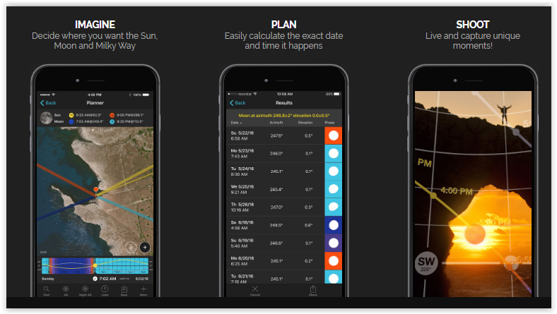
Photpills drone app: HOW IT WORKS
Have you ever walked through a place and thought: “It’s too bad the Moon isn’t RIGHT there… would have made a great photo!”? What about the Sun? and the Milky Way? Well, now you can just let your imagination fly and calculate when this specific magic moment happens in just a few seconds!
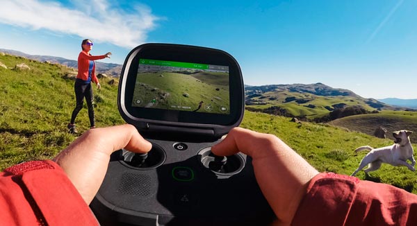
If you’re not completely happy with the DJI Go app, or even if you are, you should take a look at Litchi. It’s a great alternative, and many consider it to be superior.
It offers some pretty impressive autonomous tracking features that are great for shooting video.
Litchi’s flight modes include Panorama, Orbit me, Follow me, Ground station and Waypoints, VR Mode (Virtual Reality) and Focus.
litchi drone app for DJI drones
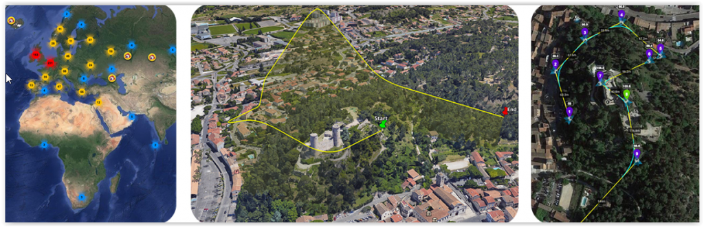
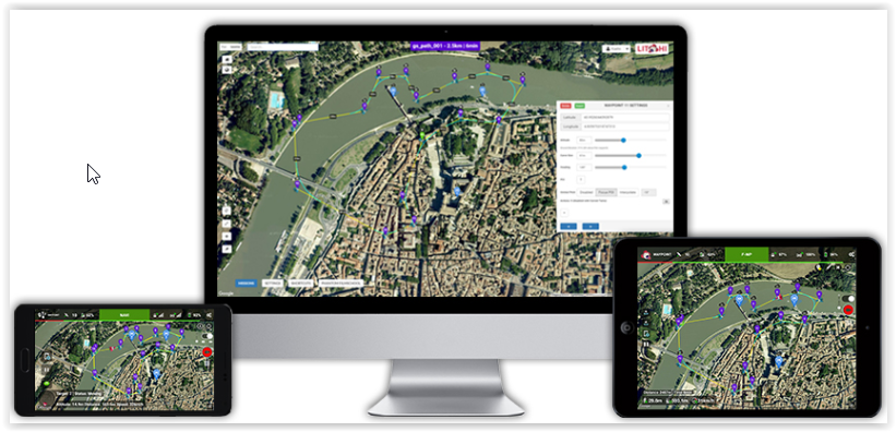
Plan waypoint missions anywhere:
Whether you are a professional or beginner, Litchi offers the most intuitive yet powerful waypoint mission engine. Our mission planner is available on all platforms including PC/Mac with seamless mission syncing across all your devices.
Litchi drone App
With Litchi drone app just focus on what matters:
Like getting that perfect shot. In Focus mode, Litchi assists you by taking control of both the gimbal and the drone’s yaw axis, so you can concentrate on horizontal movements. The result? Amazing shots. Everytime.
Immerse yourself into a new world:
By harnessing the power of your mobile phone, the Virtual Reality mode brings you the most immersive FPV experience. Watch your autonomous mission in VR mode, or fly manually for added thrills.
This utility requires goggles which are sold separately.
Litchi drone app allows tracking anything is just one touch away:
With Litchi’s Track mode, your DJI drone now understands what it sees. Using state of the art computer vision algorithms, Litchi keeps your selection perfectly framed while you fly the drone. Don’t want to fly manually? That’s ok too, start an autonomous Orbit or Follow and watch Litchi take care of everything.
Litchi drone app has different modes: Panorama, Orbit, Follow and more
Each flight mode is engineered to provide best in class results. And for added peace of mind, Litchi creates readable flight logs for each and every flight and automatically uploads them to your Airdata UAV account for instant post-flight analysis.
DJI has just released this app for serious and professional drone users who want to create complex autonomous flight paths. It’s designed to make the process of creating these paths easier by automating it.
The user selects an area on the map that he or she wants to survey, and the app automatically creates a flight path that covers the entire area, giving you the ability to adjust the amount of detail that is needed.
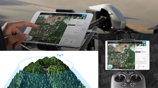
GS Pro (also known as Ground Station Pro) is an iPad app designed to controlor plan automatic flights for DJI aircraft. Through its clear, concise interface,complex flight missions can be planned with a few taps. GS Pro will thenautomatically take pictures at pre-set waypoints, providing the accuracyrequired for precision mapping.
A Virtual Fence feature increases safety andease of use by locking the aircraft’s height and speed within a designatedarea.
No products found.
With these features, GS Pro dramatically increases the efficiency ofvarious industrial applications, including but not limited to, aerial imaging, architecture, precision agriculture, electrical inspections, search and rescue,safety control, and more.
DJI Ground Station Features
DJI Ground Station works with most modern aircraft, Phantom 3 and 4, Inspire 1 and 2, Mavic, M600 and other A3 and N3 drones. Next we will highlight its main features:
Virtual Fence
Select the area where the drone is allowed to fly. GS Pro will alert you if the drone comes close to the borders and will stop it from leaving this area.
Flying in this mode also puts the drone in “Joystick” flight mode, which aggressively minimizes the drift that happens when you let go of the sticks and the aircraft still has some momentum. This makes the flight more precise since the aircraft only moves when the user requests it via stick movement when you let go of the sticks, the drone stops as quickly as possible.
Waypoint Flight
Waypoint flight lets the user specify several coordinates, and create a path for the drone to follow. It’s possible to specify settings for each waypoint (altitude, gimbal pitch, drone orientation, etc.) and also to specify actions to perform at each waypoint (start recording, stop recording take a picture, hover, etc.)
When the flight is finished, you can decide what the drone does: hover, return to home or land. Since the takeoff and landing points can be different, you could use this waypoint mode to transport objects with your aircraft.
Also, since it’s possible to record video and to orient both gimbal and drone, it can be useful for these difficult shots that you just can’t take manually.
No products found.
3D Scan Area
Another important use of waypoint flying is photogrammetry. When flying surveying missions, knowing which area is covered and maintaining a proper overlap is important. That’s why GPS based flights are so useful for this task.
Ground Station Pro offers a 3D Scan mode, that lets you specify an area to map as well as several parameters such as height, speed, and overlap.
Unlike other apps, the area doesn’t need to be a rectangle. You can specify a complex polygon and GS Pro will create the flight path for you and take the pictures at the appropriate distances. If you are an advanced user, you can also customize front and side overlap, gimbal pitch and other parameters.
GoPro’s Karma drone may have hit a few snags (the company recalled it after the first units it sold kept falling out of the sky), but when it finally becomes widely available, you’ll be able to grab a neat app called Passenger, which allows a second user to view the wireless video from the camera that’s attached to the drone.
The second user will also be able to control the camera, panning and tilting it around as the pilot controls the drone itself. In effect, that person will be able to work as the camera operator while the pilot keeps the drone flying.
GoPro’s first drone is now taking on passengers — the GoPro Passenger gives nonpilots the ability to see what the Karma camera sees, and even to handle some controls. The Passenger app was updated on the both iOS and Android app stores on Friday.
The app doesn’t take over the drone’s flight path, but allows the camera to be controlled by the “passenger.” By allowing the pilot and photographer to operate separately, GoPro says the app allows pilots to focus on just flying. Besides just being an easy way to share the pilot’s view of the flight with friends, the app could be useful for film crews using both a photographer and a drone pilot.
To prevent a stranger from accessing the Karma’s camera feed, the app has a few steps to get connected. First, the feature has to be switched on by the pilot. Then, the passenger needs to log into the Karma’s Wi-Fi system with the password.
GoPro says the app allows the passenger user to control the camera’s tilt, mode, and settings as long as it remains within the Wi-Fi range of the controller. Users can use the app to adjust the camera’s frame rate and field of view.
All Parrot drones come with a free app called FreeFlight Pro, which handles the basics of flight, providing on-screen controls and a preview of the camera image. The $20 optional Flight Plan takes this further, adding the ability for you to plan a flight, then send that information to the drone for it to fly autonomously.
You create a flight plan by selecting waypoints and how high you want the drone to be at each one. The app then calculates the path to take to fly between them, and, with the tap of a button, sends the drone along this flight path.
The flight plan for the Parrot Bebop is a quiet good tool for this Drone but the camera dont like so much the Cloudy weather. Wind was between 5 and 20 km/h so you can see the stabilisation works quiet good.
The GPS work not very accurate so you really should have a big space for landing. It lands in an area of 5 m diameter but the drone needs an bigger Area for find the right point.
Parrot Flight Plan provides autonomous flight – flawlessly
The final core add-on, as such, for the Bebop 2 is the Flight Plan. This is a software add-on (in-app purchase) for both the iOS and Android versions of FreeFlight 3. What this does is allow you to preconfigure a point-to-point flight on your device before the drone even takes off.
The functionality is very extensive. At each point that you determine satellite map, you can set preferences such as the height of the drone at each point, the speed that the drone travels between each point and any extra commands you’d like the drone to undertake while at each point (such as rotating the drone, altering the camera angle and taking a picture).
If you’re looking to get really professional footage or a first-class birds eye view, you will want to invest in the Flight Plan in-app purchase.
At £14.99, it’s pretty expensive for a software add-on, but it adds so much to the drone and allows you to fly it far further without worrying about whether the drone will go out of WiFi range.